The different levels of ocean water are continually rising, falling, and mixing together. This circulation carries oxygen to the depths and life-giving nutrients to the surface. Heat in the tropical oceans is redistributed by currents to other parts of the globe, moderating the earth's weather and climate. In turn, the winds help drive the currents, continuing the complex interaction between the oceans and the atmosphere.
Explore
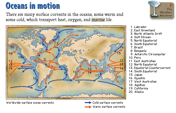
Oceans in motion
There are many surface currents in the oceans, some warm and some cold, which transport heat, oxygen, and marine life.
Worldwide surface ocean currentsCold and warm surface currents on a world map, including the Labrador, Gulf Stream, North Atlantic Drift, Antarctic Circumpolar, Peru, Japan, California, and Alaska currents, among 20 named flows.
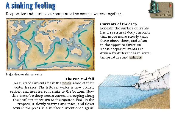
A sinking feeling
Deep-water and surface currents mix the oceans' waters together.
Currents of the deep: Beneath the surface currents lies a system of deep currents that move more slowly than those above them, and often in the opposite direction. These deeper currents are driven by differences in water temperature and salinity.
The rise and fall: As surface currents near the poles, some of their water freezes. The leftover water is now colder, saltier, and heavier, so it sinks to the bottom. Now this water's a deep-ocean current, creeping along the seafloor to return to the equator. Back in the tropics, it slowly warms and rises, and flows toward the poles as a surface current once again.
Major deep-water currentsA world map illustrating the paths of major deep-water ocean currents.
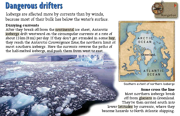
Dangerous drifters
Icebergs are affected more by currents than by winds, because most of their bulk lies below the water's surface.
Dizzying currents: After they break off from the continental ice sheet, Antarctic icebergs drift westward on the circumpolar currents at a rate of about 13 km (8 mi) per day. If they don't get stranded in some bay, they reach the Antarctic Convergence Zone, the northern limit of most southern icebergs. Here the currents reverse the paths of the half-melted icebergs, and push them from west to east.
Some cross the line: Most northern icebergs break off from glaciers in Greenland. They're then carried south into lower latitudes by currents, where they become hazards to North Atlantic shipping.
Southern extent of northern icebergsA map of the Arctic Ocean and North Atlantic showing Greenland and the southward paths icebergs travel into the Atlantic Ocean.
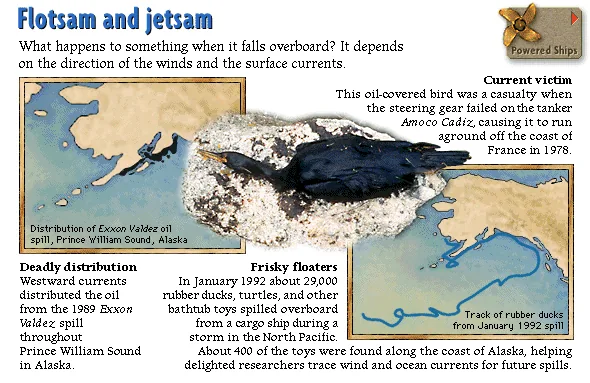
Flotsam and jetsam
What happens to something when it falls overboard? It depends on the direction of the winds and the surface currents.
Deadly distribution: Westward currents distributed the oil from the 1989 Exxon Valdez spill throughout Prince William Sound in Alaska.
Frisky floaters: In January 1992 about 29,000 rubber ducks, turtles, and other bathtub toys spilled overboard from a cargo ship during a storm in the North Pacific. About 400 of the toys were found along the coast of Alaska, helping delighted researchers trace wind and ocean currents for future spills.
Current victimThis oil-covered bird was a casualty when the steering gear failed on the tanker Amoco Cadiz, causing it to run aground off the coast of France in 1978.
Distribution of Exxon Valdez oil spill, Prince William Sound, AlaskaA map showing how westward currents spread the 1989 Exxon Valdez oil spill throughout Prince William Sound.
Track of rubber ducks from January 1992 spillA map tracing the path of rubber ducks and toys from their spill site in the North Pacific to the Alaskan coastline.
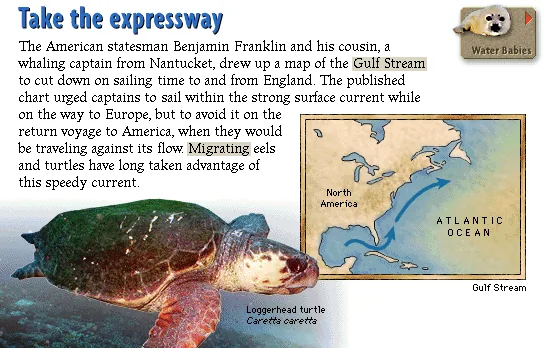
Take the expressway
The American statesman Benjamin Franklin and his cousin, a whaling captain from Nantucket, drew up a map of the Gulf Stream to cut down on sailing time to and from England. The published chart urged captains to sail within the strong surface current while on the way to Europe, but to avoid it on the return voyage to America, when they would be traveling against its flow. Migrating eels and turtles have long taken advantage of this speedy current.
Loggerhead turtleCaretta caretta
Gulf StreamA map of the North Atlantic showing the Gulf Stream current flowing from North America toward Europe.
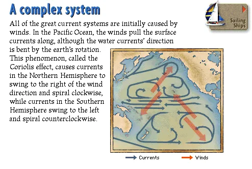
A complex system
All of the great current systems are initially caused by winds. In the Pacific Ocean, the winds pull the surface currents along, although the water currents' direction is bent by the earth's rotation. This phenomenon, called the Coriolis effect, causes currents in the Northern Hemisphere to swing to the right of the wind direction and spiral clockwise, while currents in the Southern Hemisphere swing to the left and spiral counterclockwise.
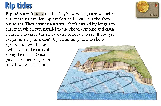
Rip tides
Rip tides aren't tides at all—they're very fast, narrow surface currents that can develop quickly and flow from the shore out to sea. They form when water that's carried by longshore currents, which run parallel to the shore, combine and cause a current to carry the extra water back out to sea. If you get caught in a rip tide, don't try swimming back to shore against its flow! Instead, swim across the current, along the shore. Once you've broken free, swim back towards the shore.
Watch
Rich rivers in the sea — Brown pelican and jumping fish
Source: Microsoft Oceans (1995) CD-ROM. Text liberated from original screen art; images, audio & clips restored from disc. Original media is Microsoft/supplier copyright — non-commercial educational preservation. Credits & Acknowledgements →