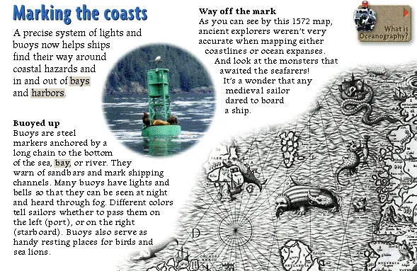
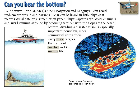
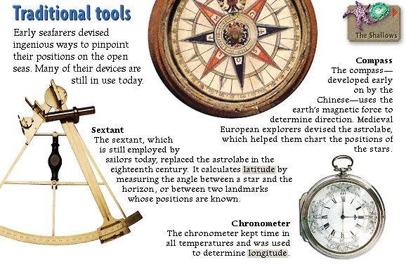
Traditional tools
Early seafarers devised ingenious ways to pinpoint their positions on the open seas. Many of their devices are still in use today.
Lost at sea? Sailors have found clever ways to know exactly where they are—from the stars overhead to satellites in space!
Lighthouses flash brilliant beams of light that can be seen for many miles. Located on especially prominent or hazardous islands or coasts, they let seamen know where they are in relation to the land. But sailors who cross entire oceans have to find their way through a large expanse of water, out of sight of any coastline. At first seafarers used the stars to fix a direction. Then they invented navigational aids like the sextant and the compass. Over time, navigation has evolved to the point where satellites, radar, and sonar can now be used to locate ships anywhere in the world, and even to map the depths of the oceans.

Early seafarers devised ingenious ways to pinpoint their positions on the open seas. Many of their devices are still in use today.

A precise system of lights and buoys now helps ships find their way around coastal hazards and in and out of bays and harbors.

Today sophisticated systems using satellites and radio beams calculate ships' positions, even in the roughest seas. The Global Positioning System (GPS)—also used in aviation and by the military—involves a number of satellites orbiting the earth. By transmitting and receiving signals, a user can determine the exact position of a vessel anywhere in the world. The Loran (long-range navigation) system, developed by the Allies for use in the Atlantic during World War II, has since expanded into a global network of transmitters. By monitoring Loran's precisely synchronized radio signals, ships and aircraft are able to determine their positions at sea.

Major canals created by humans cut thousands of miles from ships' journeys by eliminating longer routes around entire continents.

The oceans are becoming crowded with freighters, tankers, and container ships, all transporting goods and people from one part of the world to another. Radar enables these ships to keep track of one another's positions. Transmitters send out powerful energy pulses that reflect off objects, echo back, and form a picture on a screen. But it's still important to have someone on deck keeping watch!

Sound waves—or SONAR (SOund NAvigation and Ranging)—can reveal underwater terrain and hazards. Sonar can be heard in little blips as it records visual data on a screen or on paper. Ships' captains can locate channels and avoid running aground by becoming familiar with the slopes of the ocean bottom. Avoiding a disaster at sea is especially important nowadays, since commercial ships often carry toxic cargoes that can foul beaches and kill marine life!
Where are we? — The oceans are vast, and it's easy to get lost when you're out of sight of land. So every sailor needs to know the basics of how to find and keep track of a boat's position. Otherwise, you could end up almost anywhere, like on the beach of an uninhabited island like this.
Source: Microsoft Oceans (1995) CD-ROM. Text liberated from original screen art; images, audio & clips restored from disc. Original media is Microsoft/supplier copyright — non-commercial educational preservation. Credits & Acknowledgements